Settlement and night lights
Bake a seeded settlement scenario for the whole world, show farmland and towns in the colour, light the planet at night, and export the population and land-use layers.
A settlement scenario places people on your planet. Terrain and climate decide where people could live; a seed decides which regions history favoured. From that scenario Dayside can clear land for fields and towns in the satellite colour, light cities and roads at night, and export population and land-use maps. It is a scenario and makes no population prediction. The same seed and settings always give the same result.
Nothing on this page runs by itself. Every result waits for a bake: Bake settlement scenario, Reroll history or Bake night lights. Each bake is a background job that the job dock also reports, with a progress bar and Cancel.
The Settlement group#
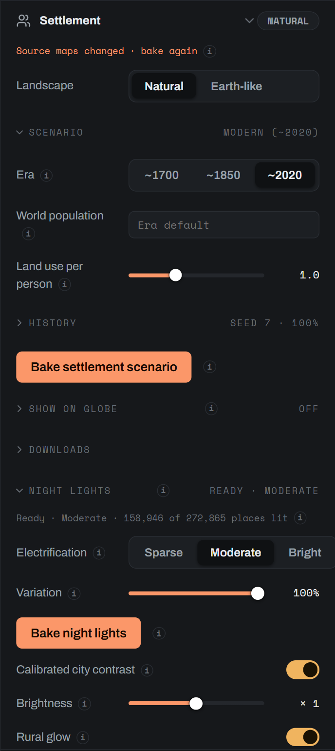
The Settlement group sits in the globe workspace's side panel, collapsed by default. Its header chip shows the landscape, or what a bake is doing.
Landscape#
Landscape chooses Natural or Earth-like for the whole world.
- Natural keeps the landscape's natural cover. A scenario can still be baked and exported without drawing it.
- Earth-like draws cleared land, fields and towns from the baked scenario. The button stays disabled until a scenario is baked, and the fields and towns show through the map-driven Look.
When the world has an authored temperature map, the group notes Authored temperature · uncalibrated: the settlement curves were fitted on Dayside's synthesised temperature, and an authored map moves people in ways Earth data has not tested.
Scenario#
| Control | Default | What it does |
|---|---|---|
| Era | ~2020 | ~1700, ~1850 or ~2020: Pre-industrial, Industrial or Modern. Each era sets land use per person, the urban share, how strongly history concentrates people and the response curves. Era totals come from HYDE 3.3. |
| World population | empty, Era default | People on the whole world. Leave it empty for the era's Earth-calibrated level, so a world with less suitable land holds fewer people. |
| Land use per person | 1.0 | 0 to 3. Scales the era's cropland, pasture and built-up land per person. 1 matches HYDE 3.3; 0 keeps natural cover. |
The era tooltips give the Earth figures behind them: 0.60 billion people and 0.55 ha of cropland per person around 1700, 1.29 billion and 0.48 ha around 1850, and 7.66 billion and 0.21 ha around 2020. The Industrial era's curves are interpolated between 1700 and 2020.
History#
| Control | What it does |
|---|---|
| Seed | A whole number, default 7. The same seed and settings always give the same scenario. |
| Reroll history | Draws a new seed and bakes. |
| History strength | 0 to 100%, default 100%. At 0 geography alone decides; at 100% regions differ as much as they do on Earth for the era. |
Bake settlement scenario#
Bake settlement scenario reads the whole world's terrain and climate. It takes minutes on a large world; Reroll history reuses the terrain step. Renders and exports queued while a bake runs are cancelled when the new scenario is published.
Show on globe#
Once a scenario exists, Show on globe draws it over the planet: Off, Suitability or Scenario. Suitability comes from terrain and climate alone and does not depend on the seed. Scenario adds a Layer select for the scenario's own fields, such as population density and the land-use shares. Opacity sets the overlay strength, and a legend under it gives the range and units.
Downloads#
The Downloads band saves the scenario directly: Suitability · 16-bit (linear, black is unsuitable and white fully suitable), Density · 16-bit log (black is nobody; the rest of the range runs on a log scale from 0.001 to 100,000 people per km²) and Receipt (JSON) with the settings, era figures, totals and data credits.
Night lights#
The Night lights band, inside the Settlement group, lights the scenario at night. It needs a baked settlement scenario.
| Control | Default | What it does |
|---|---|---|
| Electrification | Moderate | Sparse, Moderate or Bright: lit like a dimly lit, typical or brightly lit region on Earth (the 15th percentile, median and 85th percentile of NASA Black Marble 2016). |
| Variation | 100% | 0 lights every region alike. 100% varies electrification between regions as much as on Earth. The seed decides which regions. |
Bake night lights places cities and towns from the scenario, lights them and adds terrain-following connecting roads. Pre-industrial and Industrial eras are lit as if electrified. Renders and exports queued while it bakes are cancelled when the new night lights are published.
After the first bake, the look can change without another bake:
| Control | What it does |
|---|---|
| Calibrated city contrast | On uses the contrast calibrated on Earth. Off reveals City contrast, 0.60 to 1.30: how much brighter large cities are than small towns. |
| Brightness | Multiplies all light, from ×0.1 to ×10 on a log scale. |
| Rural glow | Faint light from scattered farms and hamlets. |
Save look applies contrast, brightness and rural glow without a bake. View night lights shows the saved look on the globe as an overlay layer, and Return to day view restores the map.
In the section editor#
A section inherits the world's scenario.
- The Land coverage group, under Colour, carries the same Landscape choice. It reads
Uses the globe's baked settlement scenario.once a scenario exists, andBake a settlement scenario in globe view to enable Earth-like coverage.before. Landscape choices apply to the whole world, so re-render the section after changing them. Open globe to edit scenario jumps back to the globe. - Land coverage colours, in the Colour group, chooses Farmland and urban colours (the default) or Natural colours. Natural colours keep the same coverage but paint it with vegetation and soil colours. It needs the map-driven Look, and the setting is shared with globe colouring.
- Paper maps draw settlement symbols and roads from the saved night-light bake. See Maps and projections.
Exports#
A section export offers Settlement suitability, Population density, Land-use fractions, Settlement history and Night lights once the matching bake exists. A globe export offers the same five, labelled Settlement suitability · 16-bit, Population density · 16-bit log, Land-use fractions · 16-bit set, Settlement history · 16-bit and Night lights · 16-bit set. Night-light exports include separate road light and combined emission maps, and are unavailable with a paper map style. See Exporting.
Data credits#
The settlement model was fitted to these datasets. Dayside derived curves, coefficients and per-person totals from them and redistributes none of their data. The data providers do not endorse Dayside.
- Era land-use totals: HYDE 3.3, Klein Goldewijk (2024), Utrecht University, CC BY 4.0.
- Settlement sizes and population response: GHS-POP R2023A and GHS-UCDB R2024A, © European Union 1995-2026, CC BY 4.0.
- Built-up totals and curve shape: ESA WorldCover 10 m 2021 v200, CC BY 4.0.
- Seed places: GeoNames (geonames.org), CC BY 4.0.
- Night-light patterns derived from NASA Black Marble 2016 (Credit: NASA). Not endorsed by NASA. Where the lights fall comes from the planet's own settlement model; Black Marble supplies the look of the patterns only.
The Credits tip at the foot of the Settlement group lists the same lines for the world you have open.